- Active
6001/6010 Island Highway
Qualicum Beach · Other
Listed by REMAX Professionals (NA) · MLS® 1049440
There is more to this listing. Create a free account to see the exact location, taxes, room sizes and price history.
Sign inAbout this home
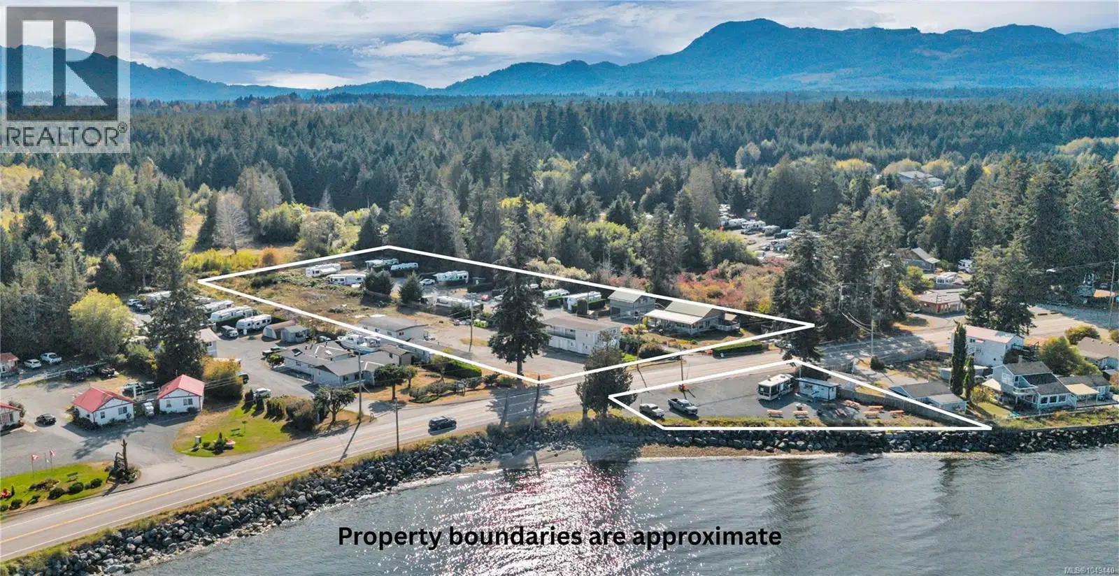
An exceptional commercial investment in Qualicum Beach, on central Vancouver Island. Located in Qualicum Bay, the offering comprises two freehold parcels totalling approximately 3.09 acres and includes a waterfront portion with about 155 feet of walk on frontage on the bay. This established mixed use property generates income across 24 units and several revenue streams: a motel style accommodation building, twelve RV pads, self contained suites, a mobile home, a 2010 rancher, suites above garage bays, and a waterfront vendor site currently home to a popular seasonal food business. Zoned C1.6 under RDN Bylaw 2500, the property offers a proven going concern today at an approximate 8.1% capitalization rate (based on 2025 income), with meaningful room to grow. Current density sits at roughly 7.8 units per acre against zoning that contemplates considerably more, leaving unused development potential for an investor or builder to explore. Several accommodation units also rent well below comparable units in the same building, a documented path to stronger returns over time. The waterfront vendor site offers a further opportunity, giving an owner operator a ready made location for a food or hospitality venture. Fronting Island Highway West in Qualicum Bay, the property enjoys steady exposure in a growing coastal corridor prized for boating, fishing, golf, and beachfront recreation. Minutes from the shops and services of Qualicum Beach and a short drive to Parksville, it sits in one of Vancouver Island's most desirable seaside communities. The five civic addresses can be operated as a single asset, held for diversified income, or repositioned in stages. Whether held for its blend of accommodation, residential, and vendor income, expanded under its existing zoning, or explored for future redevelopment, this is a versatile and scarce offering. Full financial package will be available to qualified buyers. Zoning and permitted uses to be confirmed by the buyer.
Home facts
- Property type
- Other
- Area
- Qualicum Beach
- Listed
- September 11, 2026
- Structure
- Commercial Mix
- PID
- 006-204-571
- Common interest
- Freehold
Highlights
- Ocean view
- Mountain view
- Waterfront
Features and inclusions
- Lot
- Acreage, Partially cleared
Rooms and building
- Water
- Zoning
- Unknown

The information contained on this site is based in whole or in part on information that is provided by members of The Canadian Real Estate Association (CREA), who are responsible for its accuracy. CREA reproduces and distributes this information as a service for its members and assumes no responsibility for its accuracy.
Monthly and upfront costs
Uses the posted 5-year rate (5.19%), 20% down and a 25-year amortization.
Monthly ownership costs
- Principal and interest
- $22,513
- Property tax
- $1,383/mo
- Home insurance
- $150/mo
- Estimated monthly total
- $24,047
Purchase snapshot
- List price
- $4,749,900
- Down payment
- $949,980 (20%)
- Estimated mortgage
- $3,799,920
Estimates only. They leave out utilities, upkeep and closing costs.
Borrowing costs
What money costs right now
The rates behind any payment estimate on this page.
- Prime rate
- 4.45%
- Variable mortgages are quoted against this.
- 5 year bond yield
- 3.68%
- Fixed mortgage pricing follows this.
- Policy rate
- 2.25%
- Set by the Bank of Canada.
These are benchmark rates, not mortgage quotes. Your rate depends on the lender, the term, and your file.
Source: Bank of Canada. As of 2026-09-29
Property tax
What the tax bill looks like
Municipal, regional, hospital and school rates combined.
- Estimated annual tax
- $29,406
- At 6.1908 per $1,000 of assessed value.
Estimated by applying the municipal rate to the asking price. Your actual bill is based on the BC Assessment value, which is set separately and usually differs from the sale price. Home owner grants are not included.
Source: Province of British Columbia, Local Government Statistics Schedule 702, 2026. As of 2026-01-01
Neighbourhood
Estimated travel times. Map data © OpenStreetMap contributors.
Land and hazards
What the maps say about this land
Provincial designations and mapped natural hazards at this location.
- Wildfire interface
- Low risk
- In a mapped wildland-urban interface zone. Affects insurance and FireSmart requirements.
Based on where this point falls in provincial map layers, not a site survey or a formal hazard assessment. Confirm with the municipality, a professional, and your insurer before relying on it.
Source: BC Geographic Warehouse (Agricultural Land Commission, BC Wildfire Service)
Most listed
Detached · 76%